The People's Republic of Porto Capital is divided in four states, according to ethno-cultural and linguistic lines: Extremo, Guetaso, Bajapez and Mauré. These three entities did not exist during the rule of the Maurestani Empire, when the entire Porto Capital was a part of the Province of Oran. Instead, they were created by the Federal Republic of Brolecia and the Empire of Maurestania under Ordlandic Protection in 299, immediatly following the Maurestani War. The current state borders still follow the old Brolecian and Maurestani lines.
Extremo[]


Location of Extremo within Porto Capital.
The state of Extremo (in Extreman, Extreemo) was, originally, a state within Brolecia. Following a series of direct actions by the Eçeerdytò Extreemaeenso da Liberasú (Extreman Liberation Army), two referendums on the 30th of October and the 20th of December 299 led to the establishment of a liberal Republic of Extremo. On the 27th of December, while final negotiations between Brolecia and the Republic of Extremo were taking place, armed fighters of the Eçeerdytò Extreemaeenso da Revolasú (Extreman Army of the Revolution, a spliter group of the Extreman Liberation Army) attacked the government compound in Extrema and proclaimed the socialist People's Republic of Extremo.
Due to these actions, the state of Extremo is sometimes called the Craddle of the Portocapitalian Revolution.
After the Peaceful Revolution, in late 301, Extremo was reestablished as a Portocapitalian state, with a significant majority of speakers of the Extreman language. The City of Porto Capital (in Extreman, Extreema), apart from being the capital of the People's Republic, also serves as the seat of the Extreman state government.
The governor of Extremo is Shuan Alberto Gonsalet.
Symbols[]
The new Extreman symbols, adopted on the 28th of December 315 (the 14th anniversary of the Peaceful Revolution) are its flag and coat of arms. The coat of arms is composed of a vertical tricolour of black, orange and green, the traditional colors of Extreman political entities since the First Extreman Empire of 2520BP. A red star stands for socialism, while the shield is supported by two ears of maize, the main agricultural produce of the state. On a white scroll, the phrase Vyva ļa Çente de Extreemo (Long Live the People of Extremo).
The flag of Extremo, also adopted on the 28th of December 315, is composed of a diagonal bicolour of black and green, with the coat of arms centered.
The flag of the old People's Republic of Extremo was a complex pattern involving traditional colours and repeating crosses and saltires. The first flag of the Portocapitalian state of Extremo simplified this design by transforming it into an orange cross over a green saltire on a black field.
")
")
")
")
Guetaso[]


The state of Guetaso.
The state of Guetaso, formerly known by the old Brolecian-era names Güetasão and Guwetaso, is located in the central region of Porto Capital, bordering both Extremo and Bajapez. Historically the borderlands of both the Mezapatani and Extreman cultural areas, the region was colonized by Moranguese-speaking settlers from Angliya starting on 140BP. Guetaso was first established by Brolecia as an Arosian-speaking state, later being retained with the same borders during the formation of the People's Republic, with a capital city at Rate.
Costa da Prata, originally part of Guetaso, was ceded to the Empire of Maurestania under Ordlandic Protection following a referendum on the 9th of January 302. The territory was occupied by Portocapitalian forces during the Ordlandic War in January 317, while a referendum on the 5th of January 318 confirmed its annexation by the People's Republic and reintegration into Guetaso.
The current governor of Guetaso is Daví Silva Camões.
Symbols[]
Guetaso also adopted a new set of state symbols on December 315. A new coat of arms, composed of a green field with a white diagonal band, features a band of traditional Extreman and Mezapatani arrows, decorated with the feathers of a Red Macaw, the national bird of Porto Capital. On the center, the silhouette of the Homem do Bussaco, a traditional totemic figure of the original tribes of the region. The shield is sided by two sugarcane plants, with a golden scroll featuring the text Estado do Guetaso (State of Guetaso). The state flag is a vertical tricolour of green, yellow and red, with the coat of arms centered on the yellow band.
The old Brolecian Güetasão flag was a vertical bicolour with a field unevenly divided into light green on the hoist and black on the fly, with the totemic Bussaco silhouete centered over the colour boundary. The first Portocapitalian Guetaso flag was also an off-centered bicolour, this time of red and green, with a red Bussaco on the upper part of the flag.
")
")
")
")
Bajapez[]

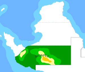
Bajapez within Porto Capital.
Bajapez, also known by the old Brolecian-era spelling Bajápes (although that form quickly lost favour), is the southernmost of the three Portocapitalian states, inhabited by a Sanpatrician-speaking majority. The state capital is the city of Oran, formerly the capital of the Maurestanian Empire.
The current governor of Bajapez is Enrique de Sousa Perez.
Symbols[]
The state of Bajapez also adopted a new set of symbols on December 315. The new coat of arms is composed of a blue shield, with a white crescent and a cross - symbolizing both the Mounist and Cruisan religions, but also the Maurestani heritage of the state. The shield is also topped by a mural crown on the shape of a traditional Mezapatani temple and a red star for socialism. The shield is supported by two palm leaves and a scroll featuring the traditional state motto in Sanpatrician: Con el honor y el valor de nuestro pueblo nosotros adelantamos (We shall advance with the honour and courage of our people).
The new state flag, also adopted on the 28th of December 315, is a horizontal tricolour of blue, white and blue, with a red band on the hoist featuring the state coat of arms. From 301 to 315, the flag of Bajapez was composed of a blue field with a thick diagonal gray band.
During Brolecian times, the flag of Bajapez/Bajápes was a tricolour of light blue, gray and light blue, with the state motto Con el honor y el valor de nuestro pueblo nosotros adelantamos in red type.
")
")
")
")
Mauré[]


Location of Mauré within Porto Capital.
The youngest of the Portocapitalian states, Mauré (in Maurestani, Mahure) was a component of the Empire of Maurestania under Ordlandic Protection. The peninsula was occupied by forces of Porto Capital's National People's Army during the opening stages of the Ordlandic War, in January 317. The Portocapitalian government announced the annexation of Mauré on August 317, while on the 10th of December the region became the "National Territory of the Mauré Peninsula", as control of the area was transfered from a military occupation government to an interim civilian administration.
On the 5th of January 318, a referendum confirmed the incorporation of Mauré into the People's Republic.
With roughly 530.000 inhabitants (320 estimative), Mauré is the least populated state of Porto Capital. It is also the only state where Maurestani speakers make up a significant minority of the population.
The state is currently governed by an interim civilian administration, headquartered on the state capital of Quassab.
Symbols[]
Mauré was granted its official symbols on the 12th of May 319. The flag and coat of arms were designed by a twenty-person committee which included political leaders, academics, artists and designers, combining both traditional Maurestani colours as well as Portocapitalian symbolism.
The new flag, heavily inspired by the Portocapitalian national flag, features both the black, white and sky-blue colours of former Maurestania as well as a traditional red star for socialism. The coat of arms features the same colours, as well as a redstar-and-cogwheel, standing for both socialism and the region's industrial economy. Below, a scroll displays the state's name in both Aro-Extreman (Mauré) and in the Maurestani language (Mahure).
")
")
Proposed states[]


The two proposed states of Maurestania and Mezapatania.
Since 304, the possibility of establishing new states within Porto Capital has been raised by the government on a number of occasions - mostly by the various local stances of the Foro, but also on the national People's Senate. The two main proposed states are Maurestania, as a Maurestani-speaking state; and Mezapatania, for the Mezapatani speakers. Both proposals have, so far, been rejected, on the grounds that neither Maurestani- nor Mezapatani-speakers make up a majority of the population on those areas.
These proposals have also met with stiff opposition from the Bajapez public, as their state would be reduced to its southern coastal area only.
| |||
|---|---|---|---|
| • Government • History • Geography • Economy • Military • (Tech Talk) • | |||
| States: Extremo • Guetaso • Bajapez • Ceremonial Districts | |||
| Main Cities: Porto Capital • Oran • Rate • Sol • Cidade d'Ouro • (See all) | |||
| Culture: Symbols • Languages • Religion • Music • Sports • Culture Test |